Žitorađa
This article may be expanded with text translated from the corresponding article in Serbian. (September 2013) Click [show] for important translation instructions.
|
Žitorađa Житорађа | |||
|---|---|---|---|
| Village and municipality | |||
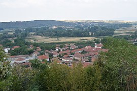
 Town panorama | |||
| |||
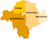
 Location of the municipality of Žitorađa within Serbia | |||
| Coordinates: 43°11′N 21°43′E / 43.183°N 21.717°E / 43.183; 21.717Coordinates: 43°11′N 21°43′E / 43.183°N 21.717°E / 43.183; 21.717 | |||
| Country | |||
| Region | Southern and Eastern Serbia | ||
| District | Toplica | ||
| Settlements | 30 | ||
| Government | |||
| • Mayor | Ivan Stanojević (SNS) | ||
| Area[1] | |||
| • Village | 21.81 km2 (8.42 sq mi) | ||
| • Municipality | 214 km2 (83 sq mi) | ||
| Elevation | 221 m (725 ft) | ||
| Population (2011 census)[2] | |||
| • Municipality | 16,368 | ||
| • Municipality density | 76/km2 (200/sq mi) | ||
| Time zone | UTC+1 (CET) | ||
| • Summer (DST) | UTC+2 (CEST) | ||
| Postal code | 18412 | ||
| Area code | +381(0)27 | ||
| Car plates | PK | ||
| Website | www.zitoradja.org | ||

Žitorađa (Serbian Cyrillic: Житорађа, pronounced [ʒîtorad͡ʑa]) is a village and municipality located in the Toplica District of the southern Serbia. The municipality includes 30 settlements. According to the 2011 census, the population of the municipality is 16,368 inhabitants.
Contents
1 Geography
2 Settlements
3 History
4 Demographics
4.1 Ethnic groups
5 Economy
6 Gallery
7 Trivia
8 Notable people
9 References
10 External links
Geography
Žitorađa is 35 km to the south-west from Niš. It lies 10 km from Corridor 10, which connects Serbia with R. Macedonia, Greece and further east.
Settlements
Location within Toplica Distrcit
Aside from the town of Žitorađa, the municipality includes the following settlements:
- Badnjevac
- Đakus
- Debeli Lug
- Donje Crnatovo
- Donji Drenovac
- Držanovac
- Dubovo
- Glašince
- Gornje Crnatovo
- Gornji Drenovac
- Grudaš
- Jasenica
- Kare
- Konjarnik
- Lukomir
- Novo Momčilovo
- Pejkovac
- Podina
- Rečica
- Samarinovac
- Smrdić
- Stara Božurna
- Staro Momčilovo
- Studenac
- Toponica
- Vlahovo
- Voljčince
- Zladovac
History
The village has its origins in the Eastern Roman (Byzantine) town "Ad Herculum" (Ad Hercules), which existed in the 4th century. The archaeological site of the Byzantine town is known as Žitoradsko kale, located on the Pasjača mountain, while a "Latin church" dating to the period is located in Glašince.
The primary school was founded in 1873. In 1877, the region was liberated from the Ottoman Empire. This event is considered the founding year of Žitorađa municipality.
Demographics
| Historical population | ||
|---|---|---|
| Year | Pop. | ±% p.a. |
| 1948 | 21,250 | — |
| 1953 | 22,427 | +1.08% |
| 1961 | 22,071 | −0.20% |
| 1971 | 21,224 | −0.39% |
| 1981 | 20,710 | −0.24% |
| 1991 | 19,545 | −0.58% |
| 2002 | 18,207 | −0.64% |
| 2011 | 16,368 | −1.18% |
| Source: [3] | ||
The municipality had 16,368 people, according to the 2011 census.
Ethnic groups
The ethnic composition of the municipality:
| Ethnic group | Population |
|---|---|
| Serbs | 14,735 |
| Roma | 1,366 |
| Montenegrins | 113 |
| Macedonians | 11 |
| Others | 143 |
| Total | 16,368 |
Economy
The economy of Žitorada is mostly based on agriculture.[4] There are 23,300 hectares of arable land.[4] The farm “December
1st” has the capacity of 30,000,000 fattened pigs per year, and it is one of the most successful in the whole of Serbia.[4]
The following table gives a preview of total number of employed people per their core activity (as of 2016):[5]
| Activity | Total |
|---|---|
| Agriculture, forestry and fishing | 92 |
| Mining | 26 |
| Processing industry | 178 |
| Distribution of power, gas and water | 13 |
| Distribution of water and water waste management | 35 |
| Construction | 91 |
| Wholesale and retail, repair | 189 |
| Traffic, storage and communication | 34 |
| Hotels and restaurants | 26 |
| Media and telecommunications | 1 |
| Finance and insurance | 3 |
| Property stock and charter | - |
| Professional, scientific, innovative and technical activities | 47 |
| Administrative and other services | 16 |
| Administration and social assurance | 121 |
| Education | 226 |
| Healthcare and social work | 137 |
| Art, leisure and recreation | 22 |
| Other services | 25 |
| Total | 1,283 |
Gallery

Town panorama
Vlahovo village panorama

Church in Vlahovo

Town center

Town Sports Hall
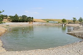
Water basin in Žitorađa


Trivia
The village was the site of the pre-ceremonial wedding of Serbian folk singer Svetlana Ražnatović "Ceca", who was born in the village, and Željko Ražnatović "Arkan", a notorious career criminal and paramilitary leader, on 19 February 1995.[6] The whole wedding was broadcast nationwide on RTV Pink.
Notable people
Ivica Dačić (b. 1966), Serbian politician (Socialist Party of Serbia), current Minister of Internal Affairs
Svetlana "Ceca" Ražnatović (b. 1973), Serbian folk singer popular throughout former Yugoslavia and Bulgaria.
Miodrag "Miki" Rakić (1975-2014), Serbian politician, who played key role in reconciliation of SPS and DS, forming of NDS and SNS, former vice president of DS and chief of staff of president Boris Tadic
References
^ "Municipalities of Serbia, 2006". Statistical Office of Serbia. Retrieved 2010-11-28..mw-parser-output cite.citation{font-style:inherit}.mw-parser-output q{quotes:"""""""'""'"}.mw-parser-output code.cs1-code{color:inherit;background:inherit;border:inherit;padding:inherit}.mw-parser-output .cs1-lock-free a{background:url("//upload.wikimedia.org/wikipedia/commons/thumb/6/65/Lock-green.svg/9px-Lock-green.svg.png")no-repeat;background-position:right .1em center}.mw-parser-output .cs1-lock-limited a,.mw-parser-output .cs1-lock-registration a{background:url("//upload.wikimedia.org/wikipedia/commons/thumb/d/d6/Lock-gray-alt-2.svg/9px-Lock-gray-alt-2.svg.png")no-repeat;background-position:right .1em center}.mw-parser-output .cs1-lock-subscription a{background:url("//upload.wikimedia.org/wikipedia/commons/thumb/a/aa/Lock-red-alt-2.svg/9px-Lock-red-alt-2.svg.png")no-repeat;background-position:right .1em center}.mw-parser-output .cs1-subscription,.mw-parser-output .cs1-registration{color:#555}.mw-parser-output .cs1-subscription span,.mw-parser-output .cs1-registration span{border-bottom:1px dotted;cursor:help}.mw-parser-output .cs1-hidden-error{display:none;font-size:100%}.mw-parser-output .cs1-visible-error{font-size:100%}.mw-parser-output .cs1-subscription,.mw-parser-output .cs1-registration,.mw-parser-output .cs1-format{font-size:95%}.mw-parser-output .cs1-kern-left,.mw-parser-output .cs1-kern-wl-left{padding-left:0.2em}.mw-parser-output .cs1-kern-right,.mw-parser-output .cs1-kern-wl-right{padding-right:0.2em}
^ "2011 Census of Population, Households and Dwellings in the Republic of Serbia: Comparative Overview of the Number of Population in 1948, 1953, 1961, 1971, 1981, 1991, 2002 and 2011, Data by settlements" (PDF). Statistical Office of Republic Of Serbia, Belgrade. 2014. ISBN 978-86-6161-109-4. Retrieved 2014-06-27.
^ "2011 Census of Population, Households and Dwellings in the Republic of Serbia" (PDF). stat.gov.rs. Statistical Office of the Republic of Serbia. Retrieved 12 January 2017.
^ abc Žitorađa Official site, Information (PDF)
^ "ОПШТИНЕ И РЕГИОНИ У РЕПУБЛИЦИ СРБИЈИ, 2017" (PDF). stat.gov.rs (in Serbian). Statistical Office of the Republic of Serbia. Retrieved 20 February 2017.
^ Laurence Mitchell, "Serbia, 2nd", p. 49
External links
| Wikimedia Commons has media related to Žitorađa. |
- Žitorađa Official website
Capital: Žitorađa | ||
| Villages |
|  |
| Notable people |
| |
Municipalities and cities of Southern and Eastern Serbia | ||
|---|---|---|
| Cities |
|  |
| Municipalities |
| |


