Sonoran Desert
| Sonoran Desert | |
|---|---|
 Saguaro National Park, Arizona | |
 Sonoran Desert | |
| Geography | |
| Countries | United States and Mexico |
| States | List
|
| Borders on | Mojave Desert (north) Colorado Plateau (north and east) Peninsular Ranges (west) |
| Coordinates | 32°15′36″N 112°55′34″W / 32.26°N 112.92611111111°W / 32.26; -112.92611111111 |
The Sonoran Desert is a North American desert which covers large parts of the Southwestern United States in Arizona and California and of Northwestern Mexico in Sonora, Baja California, and Baja California Sur. It is the hottest desert in Mexico. It has an area of 260,000 square kilometers (100,000 sq mi). The western portion of the United States–Mexico border passes through the Sonoran Desert.
In phytogeography, the Sonoran Desert is within the Sonoran Floristic Province of the Madrean Region in southwestern North America, part of the Holarctic Kingdom of the northern Western Hemisphere. The desert contains a variety of unique and endemic plants and animals, such as the saguaro (Carnegiea gigantea) and organ pipe cactus (Stenocereus thurberi).
Contents
1 Location
2 Sub-region deserts
3 Ecology
3.1 Flora
3.2 Fauna
4 Human population
4.1 California
4.2 Undocumented border crossing
5 Parks, conservation centers and research facilities
6 Gallery
7 See also
8 References
9 External links
9.1 Parks and recreation areas
Location
The Sonoran desert wraps around the northern end of the Gulf of California, from Baja California Sur (El Vizcaíno Biosphere Reserve in central and Pacific west coast, Central Gulf Coast subregion on east to southern tip), north through much of Baja California, excluding the central northwest mountains and Pacific west coast, through southeastern California and southwestern and southern Arizona to western and central parts of Sonora.[1]
It is bounded on the west by the Peninsular Ranges, which separate it from the California chaparral and woodlands (northwest) and Baja California Desert (Vizcaino subregion, central and southeast) ecoregions of the Pacific slope. To the north in California and northwest Arizona, the Sonoran Desert transitions to the colder-winter, higher-elevation Mojave, Great Basin, and Colorado Plateau deserts.
To the east and southeast, the deserts transition to the coniferous Arizona Mountains forests and Sierra Madre and Sierra Madre Occidental pine–oak forests at higher elevations. To the south the Sonoran–Sinaloan transition subtropical dry forest is the transition zone from the Sonoran Desert to the tropical dry forests of the Mexican state of Sinaloa.[1]
Sub-region deserts
The desert's sub-regions include the Colorado Desert of southeastern California; and the Yuma Desert east of the north-to-south section of the Colorado River in southwest Arizona. In the 1957 publication, Vegetation of the Sonoran Desert, Forrest Shreve divided the Sonoran Desert into seven regions according to characteristic vegetation: Lower Colorado Valley, Arizona Upland, Plains of Sonora, Foothills of Sonora, Central Gulf Coast, Vizcaíno Region, and Magdalena Region.[2] Many ecologists now consider Shreve's Vizcaíno and Magdalena regions, which lie on the western side of the Baja California Peninsula, to be a separate ecoregion, the Baja California Desert.
Within the southern Sonoran Desert in Mexico is found the Gran Desierto de Altar, with the Reserva de la Biosfera el Pinacate y Gran Desierto de Altar ('Pinacate National Park' in Mexico), extending 2,000 square kilometers (770 sq mi) of desert and mountainous regions.[3] The Pinacate National Park includes the only active Erg dune region in North America. The nearest city to the Reserva de la Biosfera el Pinacate y Gran Desierto de Altar is Puerto Peñasco (a.k.a. 'Rocky Point') in the state of Sonora, Mexico.
- Sub-regions
Sonoran Desert sub-regions include:
- Colorado Desert
- Gran Desierto de Altar
- Lechuguilla Desert
- Tonopah Desert
- Yuha Desert
- Yuma Desert
Ecology
The Sonoran Desert includes 60 mammal species, 350 bird species, 20 amphibian species, over 100 reptile species, 30 native fish species, over 1000 native bee species, and more than 2,000 native plant species.[4] The Sonoran Desert area southeast of Tucson and near the Mexican border is vital habitat for the only population of jaguars living within the United States.[5] The Colorado River Delta was once an ecological hotspot within the Sonoran desert, fueled by the flow of fresh water through the Colorado river in this otherwise dry area, but the delta has been greatly reduced in extent due to the damming and use of the river upstream.
Flora

The Sonoran Desert near Tucson, Arizona during winter.
Many plants not only survive, but thrive in the harsh conditions of the Sonoran Desert. Many have evolved to have specialized adaptations to the desert climate. The Sonoran Desert's biseasonal rainfall pattern results in more plant species than any other desert in the world.[6] The Sonoran Desert includes plant genera and species from the agave family, palm family, cactus family, legume family, and numerous others.
The Sonoran is the only place in the world where the famous saguaro cactus (Carnegiea gigantea) grows in the wild.[7]Cholla (Cylindropuntia spp.), beavertail (Opuntia basilaris), hedgehog (Echinocereus spp.), fishhook (Ferocactus wislizeni), prickly pear (Opuntia spp.), nightblooming cereus (Peniocereus spp.), and organ pipe (Stenocereus thurberi) are other taxa of cacti found here. Cactus provides food and homes to many desert mammals and birds, with showy flowers in reds, pinks, yellows, and whites, blooming most commonly from late March through June, depending on the species and seasonal temperatures.
Creosote bush (Larrea tridentata) and bur sage (Ambrosia dumosa) dominate valley floors. Indigo bush (Psorothamnus fremontii) and Mormon tea are other shrubs that may be found. Wildflowers of the Sonoran Desert include desert sand verbena (Abronia villosa), desert sunflower (Geraea canescens), and evening primroses.

Velvet mesquite (Prosopis velutina)
Ascending from the valley up bajadas, various subtrees such as velvet mesquite (Prosopis velutina), palo verde (Parkinsonia florida), desert ironwood (Olneya tesota), desert willow (Chilopsis linearis ssp. arcuata), and crucifixion thorn (Canotia holacantha) are common, as well as multi-stemmed ocotillo (Fouquieria splendens). Shrubs found at higher elevations include whitethorn acacia (Acacia constricta), fairy duster, and jojoba. In the desert subdivisions found on Baja California, cardon cactus, elephant tree, and boojum tree occur.[8]

Washingtonia filifera in Anza Borrego Desert State Park
The California fan palm (Washingtonia filifera) is found in the Colorado Desert section of the Sonoran Desert, the only native palm in California, among many other introduced Arecaceae genera and species. It is found at spring-fed oases, such as in Anza Borrego Desert State Park, Joshua Tree National Park, and the Kofa National Wildlife Refuge.[9]
Fauna
Human population
The Sonoran Desert is home to the cultures of over[quantify] seventeen contemporary Native American tribes, with settlements at American Indian reservations in California and Arizona, as well as populations in Mexico.
The largest city in the Sonoran Desert is Phoenix, Arizona, with a 2013 metropolitan population of about 4.3 million.[10][not in citation given] Located on the Salt River in central Arizona, it is one of the fastest-growing metropolitan areas in the United States. In 2007 in the Phoenix area, desert was losing ground to urban sprawl at a rate of approximately 4,000 square meters (1 acre) per hour.[11]
The next largest cities are Tucson, in southern Arizona, with a metro area population of around 1 million,[10] and Mexicali, Baja California, whose municipality also has a population of around 900,000. The municipality of Hermosillo, Sonora, has a population of around 700,000. Ciudad Obregón, Sonora, in the southern part of the desert, has a population of 375,800.[12][13]
California
The Coachella Valley, located in the Colorado Desert section of the Sonoran Desert, has a population of 365,000. Many famous Southern California desert resort cities such as Palm Springs and Palm Desert are located here.
The entrance to Palm Springs, California via Highway 62
During the winter months, from November to April, the daytime temperatures in the Coachella Valley range from 70 °F (21 °C) to 90 °F (32 °C) and corresponding nighttime lows range from 46 °F (8 °C) to 68 °F (20 °C) making it a popular winter resort destination. Due to its warm year-round climate citrus and subtropical fruits such as mangoes, figs, and dates are grown in the Coachella Valley and adjacent Imperial Valley. Imperial Valley has a total population of about 188,000 and has a similar climate to that of the Coachella Valley. Other cities include Indio, Coachella, Calexico, El Centro, Imperial, Palm Desert and Blythe.
Undocumented border crossing
Straddling as it does the US-Mexican border, with low levels of human-installed security, the Sonoran desert is a popular route to attempt unauthorized entry across the border. The harsh conditions mean that the 3-5-day march, usually moving at night to minimize exposure to the heat, often ends in death.[14]
Parks, conservation centers and research facilities

Mexican goldpoppies in the Sonoran Desert National Monument
There are many National Parks and Monuments; federal and state nature reserves and wildlife refuges; state, county, and city parks; and government or nonprofit group operated natural history museums, science research institutes, and botanical gardens and desert landscape gardens.
- Index: Protected areas of the Sonoran Desert
- Index: Protected areas of the Colorado Desert
- Sonoran Desert protected areas include
- Arizona–Sonora Desert Museum
Sonoran Desert National Monument [15]
Boyce Thompson Arboretum State Park—Sonoran Desert flora arboretum
- Anza–Borrego Desert State Park
- Organ Pipe Cactus National Monument
- Saguaro National Park
- Joshua Tree National Park
Reserva de la Biosfera el Pinacate y Gran Desierto de Altar—Pinacate National Park, in Sonora, Mexico
- Indio Hills Palms State Reserve
- Coachella Valley National Wildlife Refuge
- Cabeza Prieta National Wildlife Refuge
- Kofa National Wildlife Refuge
- South Mountain Park
- Sonoran Arthropod Studies Institute
Gallery

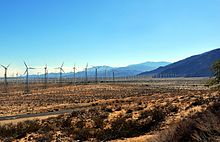
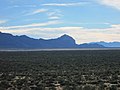
Sonoran Desert near Maricopa, Arizona
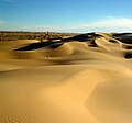
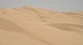
Sand dunes in the Gran Desierto de Altar
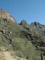
The Santa Catalina Mountains in the Sonoran Desert near Tucson, Arizona
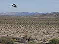
A US Border Patrol helicopter along El Camino Del Diablo, a historic 250-mile trail in the Sonoran Desert

Sand dunes at El Pinacate Biosphere Reserve in northwestern Sonora, Mexico

A saguaro forest in the Tucson Mountains of Arizona
A mesquite forest with the Santa Rita Mountains in the background
The Algodones Dunes in southeastern California


See also
- Mountain Ranges of the Sonoran Desert
- Spanish missions in the Sonoran Desert
- Deserts of the Lower Colorado River Valley
- Dust storm
List of ecoregions in the United States (EPA) (the Sonoran Basin and Range is item 81 on the map)- List of ecoregions in the United States (WWF)
- Chihuahuan Desert
- Mojave Desert
- List of deserts by area
References
^ ab "Arizona-Sonora Desert Museum, Tucson, AZ - Zoo, Botanical Garden and Art Gallery". www.desertmuseum.org. Retrieved 15 April 2018..mw-parser-output cite.citation{font-style:inherit}.mw-parser-output q{quotes:"""""""'""'"}.mw-parser-output code.cs1-code{color:inherit;background:inherit;border:inherit;padding:inherit}.mw-parser-output .cs1-lock-free a{background:url("//upload.wikimedia.org/wikipedia/commons/thumb/6/65/Lock-green.svg/9px-Lock-green.svg.png")no-repeat;background-position:right .1em center}.mw-parser-output .cs1-lock-limited a,.mw-parser-output .cs1-lock-registration a{background:url("//upload.wikimedia.org/wikipedia/commons/thumb/d/d6/Lock-gray-alt-2.svg/9px-Lock-gray-alt-2.svg.png")no-repeat;background-position:right .1em center}.mw-parser-output .cs1-lock-subscription a{background:url("//upload.wikimedia.org/wikipedia/commons/thumb/a/aa/Lock-red-alt-2.svg/9px-Lock-red-alt-2.svg.png")no-repeat;background-position:right .1em center}.mw-parser-output .cs1-subscription,.mw-parser-output .cs1-registration{color:#555}.mw-parser-output .cs1-subscription span,.mw-parser-output .cs1-registration span{border-bottom:1px dotted;cursor:help}.mw-parser-output .cs1-hidden-error{display:none;font-size:100%}.mw-parser-output .cs1-visible-error{font-size:100%}.mw-parser-output .cs1-subscription,.mw-parser-output .cs1-registration,.mw-parser-output .cs1-format{font-size:95%}.mw-parser-output .cs1-kern-left,.mw-parser-output .cs1-kern-wl-left{padding-left:0.2em}.mw-parser-output .cs1-kern-right,.mw-parser-output .cs1-kern-wl-right{padding-right:0.2em}
^ "Sonoran Desert: An Overview of the Sonoran Desert by William G. McGinnies". 21 January 2003. Archived from the original on 21 January 2003. Retrieved 15 April 2018.
^ http://www.bajaquest.com/penasco/pinacate.htm
^ Surviving the Sonoran Archived 2010-04-30 at the Wayback Machine.
^ The Jaguar in the Borderlands of Arizona, New Mexico and Northern Mexico: Conservation—Threats & Strategies Archived 2009-03-30 at the Wayback Machine.
^ "Sonoran desert". Terrestrial Ecoregions. World Wildlife Fund.
^ "The Saguaro Cactus" (PDF). nps.gov. Retrieved 15 April 2018.
^ MacMahon, J. A. Deserts. 1986, 638 pages
^ Hogan, C. M. 2009. California Fan Palm: Washingtonia filifera, GlobalTwitcher.com, ed. N. Stromberg Archived 2009-09-30 at the Wayback Machine.
^ ab Table 1: Annual Estimates of the Population of Metropolitan and Micropolitan Statistical Areas: April 1, 2000 to July 1, 2006 (CBSA-EST2006-01) Archived July 10, 2007, at WebCite, United States Census Bureau, 2007-04-05. Accessed 2007-09-11
^ Make No Small Plans, Adelheid Fischer, ASU Research magazine. Accessed on line October 15, 2007
^ Principales resultados por localidad 2005 Archived 2007-03-16 at the Wayback Machine., Instituto Nacional de Estadística Geografía e Informática (Mexico). Accessed on line October 15, 2007
^ Population Projections Archived 2007-12-22 at the Wayback Machine., state government of Baja California, Mexico. Accessed on line October 15, 2007
^ Arizona: Naming the dead from the desert, BBC News, 17 January 2013
^ The Sonoran Desert National Monument was created in 2001 in Arizona, to enhance protection of the unique resources of the Sonoran Desert, with 2,008 square kilometers (496,000 acres).
:Reference: Sonoran Desert National Monument Archived 2009-01-26 at the Wayback Machine., Bureau of Land Management, U. S. Department of the Interior. Accessed on line June 17, 2009.
External links
| Wikivoyage has a travel guide for California Desert. |
| Wikimedia Commons has media related to Sonoran Desert. |
Arizona–Sonora Desert Museum
- {https://www.desertmuseum.org/images/csds/sonoran_map-lg.jpg Map of the Sonoran Desert Ecoregion]
Sonoran Desert and its subdivisions — with photos.
- Timeline of the Sonoran desert
An Overview of the Sonoran Desert, by William G. McGinnies- The Sonoran Desert Naturalist
- Very short overview of Sonoran Desert Geology
"Sonoran desert (World Wildlife Fund)". Terrestrial Ecoregions. World Wildlife Fund.
Sonoran Desert images at bioimages.vanderbilt.edu (slow modem version)- International Sonoran Desert Alliance
Sounds of the Sonoran Desert)
Parks and recreation areas
- Sonoran Desert National Monument: official website
- Saguaro National Park: official website
- Anza–Borrego Desert State: official website
- Organ Pipe Cactus National Monument: official website
- Joshua Tree National Park: official website
- South Mountain Park—Preserve
Colorado River system | |||||||||
|---|---|---|---|---|---|---|---|---|---|
| Jurisdictions |
|     | |||||||
| Canyons |
| ||||||||
| Natural features |
| ||||||||
| Tributaries |
| ||||||||
| Engineering |
| ||||||||
| Designated areas |
| ||||||||
| Related topics |
| ||||||||
Coordinates: 32°15′36″N 112°55′34″W / 32.26000°N 112.92611°W / 32.26000; -112.92611
Authority control |
|
|---|


