圣文森特岛
| 本条目需要擴充。(2015年5月5日) |
| 當地名稱:Saint Vincent | |
|---|---|
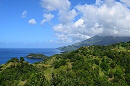 View of Saint Vincent | |
 Location of Saint Vincent in Saint Vincent and the Grenadines | |
| 地理 | |
| 位置 | 加勒比海 |
| 坐标 | 13°15′N 61°12′W / 13.250°N 61.200°W / 13.250; -61.200 |
| 群岛 | Windward Islands |
| 面積 | 345平方公里(133平方英里) |
| 长度 | 29千米(18英里) |
| 宽度 | 18千米(11.2英里) |
| 最高海拔 | 1,234米(4,049英尺) |
| 最高點 | 蘇弗里耶爾火山 |
| 管轄 | |
圣文森特和格林纳丁斯 | |
| 区 | 6 |
| 选区 | 15 |
| 最大聚居地 | Kingstown(人口25,418) |
| 人口统计 | |
| 人口 | 100,000(2012) |
| 人口密度 | 347.83人/平方公里(900.88人/平方英里) |
| 族群 | 黑人 66%, East Indian 6%, Carib people 2%, Mixed Race 19%, White 4%, Other 3%. |

聖文森特島(Saint Vincent)是聖文森特和格林納丁斯的火山島,位於加勒比海,屬於向風群島的一部分,長29公里、寬18公里,面積345平方公里,最高點海拔高度1,233米,主要經濟活動有農業和旅遊業。
外部連結
- U.S. Department of State profile
- St. Vincent and the Grenadines / San Vicente y Las Granadinas Constitution of 1979
- Map
- Hairouna


