特立尼达岛
| 本条目需要擴充。(2013年2月11日) |
當地名稱:La Isla de la Trinidad 綽號:Land of the Hummingbird | |
|---|---|
 Map of Trinidad and Tobago | |
| 地理 | |
| 位置 | 東加勒比 |
| 坐标 | 10°27′38″N 61°14′55″W / 10.46056°N 61.24861°W / 10.46056; -61.24861坐标:10°27′38″N 61°14′55″W / 10.46056°N 61.24861°W / 10.46056; -61.24861 |
| 面積 | 4,748平方公里(1,833平方英里) |
| 最高海拔 | 940米(3,080英尺) |
| 最高點 | El Cerro del Aripo |
| 管轄 | |
千里達及托巴哥 | |
| Island | 千里達 |
| 首府城市 | 西班牙港 |
| 最大聚居地 | 查瓜納斯(人口83,516) |
| 總理(Prime Minister) | Keith Rowley |
| 人口统计 | |
| 居民稱謂 | Trinidadian Trini |
| 人口 | 1,267,145[1](2011) |
| 人口密度 | 266人/平方公里(689人/平方英里) |
| 語言 | English (official and lingua franca), Trinidadian English Creole (lingua franca), Trinidadian Hindustani, Antillean French Creole, Chinese, Spanish[2][3] |
| 族群 | Indian, African, Multiracial (non-Dougla), Dougla (Indian-African), Indigenous Amerindian, European, Chinese, Arab, Hispanic or Latino[3] |
| 其他资料 | |
| 时区 |
|
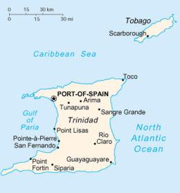
特立尼达岛(英语:Trinidad Island;西班牙语:Isla Trinidad),港澳台譯作千里达,是特立尼达和多巴哥两主岛中较大者,位于西印度群岛最西南部,距南美洲大陆委内瑞拉海岸仅11公里。特立尼达岛面积4,768平方公里,是西印度群岛中第六大岛,也是小安的列斯群岛中面积最大者。
克里斯托弗·哥伦布于1498年发现该岛[4],因岛上三座并列的山峰而将该岛命名为“特立尼达”,意为“三位一体”。此后该岛长期被西班牙占有,直到1797年转入英国手中,1888年与多巴哥岛组成联合殖民地,1962年获得独立[4]。
该岛资源丰富,出产石油、天然气和沥青,矿业为支柱产业。
参考资料
参考
^ Trinidad and Tobago 2011 Population and Housing Census Demographic Report (PDF). Trinidad and Tobago Central Statistical Office: 26. [27 May 2016].
^ https://www.ethnologue.com/country/tt/languages
^ 3.03.1 CIA Factbook
^ 4.04.1 特立尼达铁路地图. World Digital Library. 1925 [2013-10-25].
| ||||||||||||||||||||||||||||

|


