Nanjiang County
Nanjiang County .mw-parser-output .nobold{font-weight:normal} 南江县 | |
|---|---|
| County | |
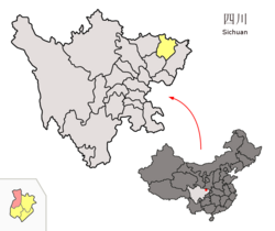 Location of Nanjiang County (red) within Bazhong City (yellow) and Sichuan | |
| Country | People's Republic of China |
| Province | Sichuan |
| Prefecture-level city | Bazhong |
| Time zone | UTC+8 (China Standard) |
Nanjiang County (Chinese: 南江县; pinyin: Nánjiāng Xiàn) is a county in the northeast of Sichuan Province, China, bordering Shaanxi province to the north. It is under the administration of Bazhong city.
Climate
| Climate data for Nanjiang (1981−2010) | |||||||||||||
|---|---|---|---|---|---|---|---|---|---|---|---|---|---|
| Month | Jan | Feb | Mar | Apr | May | Jun | Jul | Aug | Sep | Oct | Nov | Dec | Year |
| Record high °C (°F) | 19.3 (66.7) | 23.2 (73.8) | 31.9 (89.4) | 33.9 (93) | 38.4 (101.1) | 37.4 (99.3) | 40.2 (104.4) | 40.3 (104.5) | 37.7 (99.9) | 31.1 (88) | 26.2 (79.2) | 19.4 (66.9) | 40.3 (104.5) |
| Average high °C (°F) | 9.6 (49.3) | 11.9 (53.4) | 16.7 (62.1) | 22.4 (72.3) | 26.9 (80.4) | 29.3 (84.7) | 31.3 (88.3) | 31.4 (88.5) | 26.2 (79.2) | 21.0 (69.8) | 16.1 (61) | 10.5 (50.9) | 21.1 (70) |
| Daily mean °C (°F) | 5.1 (41.2) | 7.4 (45.3) | 11.4 (52.5) | 16.5 (61.7) | 20.8 (69.4) | 23.8 (74.8) | 25.8 (78.4) | 25.5 (77.9) | 21.2 (70.2) | 16.1 (61) | 11.2 (52.2) | 6.3 (43.3) | 15.9 (60.7) |
| Average low °C (°F) | 2.1 (35.8) | 4.2 (39.6) | 7.6 (45.7) | 12.1 (53.8) | 16.2 (61.2) | 19.6 (67.3) | 22.0 (71.6) | 21.5 (70.7) | 17.9 (64.2) | 13.1 (55.6) | 8.0 (46.4) | 3.5 (38.3) | 12.3 (54.2) |
| Record low °C (°F) | −4.8 (23.4) | −2.3 (27.9) | −2.8 (27) | 2.1 (35.8) | 8.0 (46.4) | 12.5 (54.5) | 15.5 (59.9) | 13.3 (55.9) | 11.0 (51.8) | −0.3 (31.5) | −1.6 (29.1) | −6.1 (21) | −6.1 (21) |
| Average precipitation mm (inches) | 5.5 (0.217) | 12.3 (0.484) | 24.8 (0.976) | 65.7 (2.587) | 128.6 (5.063) | 158.5 (6.24) | 266.2 (10.48) | 203.8 (8.024) | 180.0 (7.087) | 76.5 (3.012) | 36.6 (1.441) | 9.0 (0.354) | 1,167.5 (45.965) |
| Average relative humidity (%) | 72 | 70 | 67 | 69 | 70 | 75 | 79 | 77 | 80 | 80 | 78 | 76 | 74 |
| Source: China Meteorological Data Service Center[1] | |||||||||||||
Coordinates: 32°21′12″N 106°50′34″E / 32.35333°N 106.84278°E / 32.35333; 106.84278
References
^ 中国地面气候标准值月值(1981-2010) (in Chinese). China Meteorological Data Service Center. Retrieved 20 October 2018..mw-parser-output cite.citation{font-style:inherit}.mw-parser-output q{quotes:"""""""'""'"}.mw-parser-output code.cs1-code{color:inherit;background:inherit;border:inherit;padding:inherit}.mw-parser-output .cs1-lock-free a{background:url("//upload.wikimedia.org/wikipedia/commons/thumb/6/65/Lock-green.svg/9px-Lock-green.svg.png")no-repeat;background-position:right .1em center}.mw-parser-output .cs1-lock-limited a,.mw-parser-output .cs1-lock-registration a{background:url("//upload.wikimedia.org/wikipedia/commons/thumb/d/d6/Lock-gray-alt-2.svg/9px-Lock-gray-alt-2.svg.png")no-repeat;background-position:right .1em center}.mw-parser-output .cs1-lock-subscription a{background:url("//upload.wikimedia.org/wikipedia/commons/thumb/a/aa/Lock-red-alt-2.svg/9px-Lock-red-alt-2.svg.png")no-repeat;background-position:right .1em center}.mw-parser-output .cs1-subscription,.mw-parser-output .cs1-registration{color:#555}.mw-parser-output .cs1-subscription span,.mw-parser-output .cs1-registration span{border-bottom:1px dotted;cursor:help}.mw-parser-output .cs1-hidden-error{display:none;font-size:100%}.mw-parser-output .cs1-visible-error{font-size:100%}.mw-parser-output .cs1-subscription,.mw-parser-output .cs1-registration,.mw-parser-output .cs1-format{font-size:95%}.mw-parser-output .cs1-kern-left,.mw-parser-output .cs1-kern-wl-left{padding-left:0.2em}.mw-parser-output .cs1-kern-right,.mw-parser-output .cs1-kern-wl-right{padding-right:0.2em}
This Sichuan location article is a stub. You can help Wikipedia by expanding it. |


